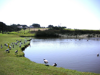
I often take for granted how beautiful it is here in town. This is pretty much the views we get while driving home from the grocery store, although this day we were walking and exploring. On one side is the Pacific Ocean and on the other is Point Pinos Lighthouse and the Pacific Grove Golf Links with Crespi Pond.
Shoreline Park is a designation that the City of Pacific Grove calls public access coastal areas not otherwise designated as city parks. For the purposes of this blog and location labels, I consider all the unpaved path around the peninsula as Pacific Grove Shoreline Park, starting from Lover's Point (not Hopkins Marine Station) and ending where Asilomar State Beach begins. Ocean View Blvd. transitions to Sunset Dr. next to this unpaved path. I've called this the "poor man's 17-Mile Drive" previously on my blog. It's usually a great place to explore tide pools.
Shoreline Park is a designation that the City of Pacific Grove calls public access coastal areas not otherwise designated as city parks. For the purposes of this blog and location labels, I consider all the unpaved path around the peninsula as Pacific Grove Shoreline Park, starting from Lover's Point (not Hopkins Marine Station) and ending where Asilomar State Beach begins. Ocean View Blvd. transitions to Sunset Dr. next to this unpaved path. I've called this the "poor man's 17-Mile Drive" previously on my blog. It's usually a great place to explore tide pools.


3 comments:
Oh!, friend and I got lost last night, took 68 wrong way trying to reach 1, and found this stretch of road, and my thought too--poor guys 17 mile drive--we had just come from 17 mile, friends first visit to thereabout...heard, 'must be nice', more than a few times!
A nice piece of work.
David, you're in town! It's easy to get turned around on the Peninsula. Nice thing about Pacific Grove vs. Pebble Beach is that we don't charge $ for the views. A little hint - if you're heading downhill, then you're bound to meet the ocean.
Thanks, Bob. Apologies for the excessive posts yesterday. Was trying to get it in presentable shape for someone in particular.
Post a Comment