Saturday, May 14, 2011

CA poppy ~ 05/14/11 ~ Marina City


This is the first time I've ever seen creamy-white variants of the California poppy... and it was in a shopping center parking lot in only one spot out of numerous flower beds filled with solid orange poppies. Wikipedia and several Flickr photos call this an albino. Can plants be considered albino? I thought the term only applied to animals, but I could be wrong.

I like how these photos also feature the red ring that distinguishes this poppy from others. Usually I have to turn the flower over to look for the red ring at the base. And, yes, I do check, because there are around 6 species of Eschscholzia in the area. Shown above, the red rings are still attached to the developing seed pods.

habitat ~ 05/14/11 ~ Fort Ord - Army Lands

Fort Ord - Army Lands
May 14, 2011

Thanks to the U.S. Army's Fort Ord Community Relations Office we joined a guided nature walk inside this non-public impact area (no pun intended). Eventually in 2020 this land will be turned over to the U.S. Department of the Interior's Bureau of Land Management (BLM) to expand the existing Public Lands to 15,000 acres. I've mentioned a couple times that the Fort Ord BLM Lands are my favorite local hiking spots (Creekside and Inter-Garrison), so it was exciting to get a glimpse of what will be.

I can't say I comprehend the process it takes to comply with all the laws and regulations, let alone the basic removal of potential explosives and lead contamination. There are so many entities involved and numerous websites; the best ones I've found are Fort Ord Reuse Authority (FORA) sites, old and new, and Former Fort Ord Environmental Cleanup. The Army's Munitions Clearance Program and Prescribed Burn Program are closely tied together, so I'll focus on the burn areas we toured.


the bunker

We were given a couple route options, and we chose the hike that led up to the bunker where the surrounding areas were burned in 2003 and 2008. While it was a quick pace to keep ahead of the more leisurely group behind us that did not hike up to the bunker, I'm glad we did.


2003 burn area

I suspect this area on top of the sandy hill was a different habitat type than those shown below. Therefore, looking at vegetative growth post-fire doesn't compare for the 2003 burn. Most of the endangered and threatened plant species we saw were found here.


2008 burn area

Shrubs, like silver bush lupine (Lupinus albifrons var. albifrons) and yellow bush lupine (Lupinus arboreus) have had enough time to grow back since 2008.


October 2009 burn area

This was the first year I was at home to see the smoke plume from home. I took a picture and made note of it here on Nature ID for October 6, 2009.


October 2010 burn area

Again, I took a picture of this particular 2010 burn from home and posted about it here on Nature ID for October 8, 2010. They also burned in September of 2010. I had expressed an interest to "tag along with the biology folks as they evaluate the September vs. October burn areas next spring." While I doubt a study like this is happening, I was so pleased to see fire poppies for the first time ever.


planned 2011 burn area in the distance

Yep, there'll be more fires through this decade until at least 2020. The first prescribed burn was conducted in 1997. Imagine over 20 years of regular fire, weather, and wildflower data?


vernal pool with soil excavation in 2008 burn area

The light green area in the center of both photos above is the same vernal pool from different vantage points. In the second photo, there's a wall to the right where soldiers trained to fire into the hill on the left. Due to accumulated munitions, the soil on the hill was excavated to sample and remove lead contamination.


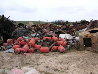
"iron triangle"

As the cleanup process continues, various Army equipment used for target practice and heavier materials (and illegal dumping like the clothes dryer shown in the middle) get collected here in what is affectionately called the "iron triangle." A contractor will come in to recycle what can be recycled and haul off the rest... except for the Cold-War era tank 21 (last picture above), which will be kept as a historic display for the BLM. To read more about the history of Fort Ord, check out The California Military Museum's website.

CA striped racer ~ 05/14/11 ~ Fort Ord


California striped racer
Coluber lateralis lateralis

Contrary to its common name, this striped racer was laying quite still in a ditch to the side of the road. While I did get fairly close, maybe too close than I should have, I did zoom and crop for the lovely close-up shot. The yellow stripe consists of 2 half-scales. The federally and state threatened C. lateralis euryxanthus has an additional fully yellow-colored scale in between the 2 half-scales.

fire poppy ~ 05/14/11 ~ Fort Ord

Papaver californicum
Papaveraceae

I've wanted to see a fire poppy ever since I read about them in Wildflowers of Monterey County. They only bloom the year after a fire. This area was burned in the fall of 2010. Gail, one of our field guides, said she has never seen them bloom so profusely. You'll have to click on the photo to enlarge the image enough to even see the orange dots. I was surprised to see how tall the stalks were for such small poppies. Unfortunately, this is the closest I could get due to the reasons for the burning - unexploded ordinance location and removal. Erg.

coastal sagewort ~ 05/14/11 ~ Fort Ord

coastal sagewort / beach sagebrush
Artemisia pycnocephala
Asteraceae

The first time I remembered the word Artemisia was during a conversation with a friend two months ago. The smell of crushed leaves from CA's native Artemisia reminds him of his childhood in England where he knew A. absinthium as wormwood. His nanny made him drink a tea of it once a month to prevent intestinal worms. I don't think it was a pleasant memory. It amazes me how scents stick in our memories and instantly transport us years to the past.

The above ID is my best guess based on looking at CNPS updated 2010 plant list for Fort Ord with 5 species of Artemisia listed out of 41 sp./ssp. found in California according to Calflora. Also shown above is western bracken fern and what I believe is white-flowering wedge-leaved horkelia (Horkelia cuneata). This area was burned in 2010.

ps 10/20/11 - After again looking at different Artemisia, I'm more positive of this ID now.

CA dandelion ~ 05/14/11 ~ Fort Ord


The inflorescence on this dandelion seemed much larger than the invasive common dandelion (Taraxacum officinale) that I usually see in lawns. I asked our long-legged guide Chris, who had already quickly passed a profusion of these flowers, what this was. She doubled-back to answer my question. I was surprised to find out there are native dandelions. In fact, a quick check of Calflora shows there are 39 species/subspecies of native dandelions in multiple genera with a few endangered, rare, or presumed extinct. Hey, learn something new everyday. I'm guessing M. californica and M. glabrata (smooth desert dandelion) are difficult to distinguish in areas where both species/varieties occur. This flower was found in an area that was burned in 2009.

cream cups ~ 05/14/11 ~ Fort Ord


I'm amazed at the color variation of cream cups where some have the yellow on the outer edges of the petals (click on the common name above to see CalPhotos' collection). While I usually don't fiddle with enhancing photos, except for cropping, I darkened these to show the detail of the flower. Otherwise, it would have looked like a bright yellow fuzzy blob. Again, I could not get closer to take a better picture due to the continuing munitions removal. These were found in an area that was burned in 2009.

seaside bird's-beak ~ 05/14/11 ~ Fort Ord

One of our guides Chris tried to point this small plant out to me a couple times during our walk. She said to look for the "little red, 6 inch tall, Charlie Brown Christmas tree." I totally missed seeing it, until she tossed a little rock to the base of the plant. She felt this younger stage of its growth was its cutest. There are very few pictures online of this particular subspecies. It is listed in the state of California as endangered. I believe this was found in an area that was burned in 2003.

sand gilia and Monterey spineflower ~ 05/14/11 ~ Fort Ord


sand gilia and Monterey spineflower
Gilia tenuiflora ssp. arenaria and Chorizanthe pungens var. pungens
CNPS 8th Edition Inventory and CNPS 8th Edition Inventory
Polemoniaceae and Polygonaceae

This pretty little purple sand gilia, aka Monterey gilia, is listed as federally endangered and threatened in the state of CA. The dusty-pink clumps to the right in each picture is the Monterey spineflower.  I believe these pictures were taken in a 2003 burn area. The white flowers shown in the second picture are popcorn flowers (Plagiobothrys sp.) in Boraginaceae. Considering there are at least 7 species of popcorn flowers found at Fort Ord, I'm not going to attempt to identify it tonight from the fuzzy photo. 

Monterey spineflower ~ 05/14/11 ~ Fort Ord

This particular variety of spineflower is listed as federally threatened. To see closeup pictures of this flower, check out my recent sand gilia pictures, then click on each photo to enlarge, and look for the pink spiky clumps to the right of each picture. The purple flowers with yellow-tips are purple owl's-clovers.

I may have walked by Monterey spineflowers many times on the Fort Ord BLM Lands and never knew it was considered likely to become endangered. I would have loved to have better closeup shots. However, being on Fort Ord Army Lands, we were instructed to strictly stay on the path for our own safety due to continuing munitions removal. I believe the above picture was taken in an area that was burned in 2003.

For those who live north of me in Santa Cruz, Santa Clara, and San Francisco counties, the other variety C. pungens var. hartwegiana (Ben Lomond spineflower) is listed as federally endangered.

coast horned lizard ~ 05/14/11 ~ Fort Ord

coast horned lizard
Phrynosoma blainvillii

I've said from the get-go that Nature ID does not show many of the cool things I see during hikes, nor is this blog a decent representation of what can be found on the Central Coast of California. You may have noticed I mainly post pictures of flowers, and it's NOT because I'm particularly more interested in plants than say birds or marine life. The great thing about taking pictures of plants is that they hold still, except when the wind blows. Plus, I can generally get close enough to take a decent picture. Flowers don't run, swim, or fly away. Unfortunately, sometimes the clearest pictures I get of animals is if they're dead, like this red-breasted nuthatch post. Even so, I was surprised to see this flattened coast horned lizard since this was on restricted Army Lands, and I can't imagine much traffic goes through on this road. Poor thing. Click this highlighted link to see much cuter (and alive!) pictures of juvenile coast horned lizards I found on Fort Ord BLM Lands on August 4, 2010.

purple owl's-clover ~ 05/14/11 ~ Fort Ord


Orobanchaceae (formerly Scrophulariaceae)

It is with many thanks to Mark Eggar on Flickr with his impressive knowledge and photo collection of Castilleja that I was able to obtain expert ID for the purple owl's clover variety/subspecies. My policy for Nature ID is to never use other people's photos and only quote if I have written permission. Seeing as how I don't have permission from Mark, yet, click on this link to my Flickr post for his comment about why these Castilleja are unusual to ID. As a note, the ongoing 2006 CNPS vascular plant list for Fort Ord (alphabetical) does not include this subspecies.

I could not decide which photo was better, the clearer first one with the non-native foxtail chess (Bromus madritensis ssp. rubens) in Poaceae or the second pic with chamise (Adenostoma fasciculatum) in Rosaceae, so I posted both. The third pic centers on older C. exserta var./ssp. latifolia with what I believe is white-flowering wedge-leaved horkelia (Horkelia cuneata) in Rosaceae to the top right. The last photo above shows this Castilleja growing among sky lupine (Lupinus nanus) in Fabaceae and non-native sheep sorrel (Rumex acetosella) in Polygonaceae, as well as many other plants. These were found in areas that were burned in 2003, 2008, or 2009.

ps 06/02/11 - I've added additional ID's in the text based on Cindy's comment below.

cobweb thistle ~ 05/14/11 ~ Fort Ord

cobweb thistle
Cirsium occidentale
Asteraceae

According to Jepson Online Interchange, there are 7 native varieties of cobweb thistle found in California. Two of those, C. occidentale var. occidentale (cobweb thistle) and C. occidentale var. venustum (venus thistle), are recorded for Fort Ord by the California Native Plant Society. Without the flower I have no clue as to which variety this one is. Quite honestly, while I reference Jepson as I search for information, I don't really understand its descriptions when distinguishing between closely related plants. Several of these thistle were found in a 2009 burn area.

western bracken fern ~ 05/14/11 ~ Fort Ord


western bracken fern
Pteridium aquilinum var. pubescens
Dennstaedtiaceae

I generally think of ferns as growing in heavily shaded areas near water sources, like at Garland Ranch Regional Park, Butano State Park, and Wilder Ranch State Park. However, this native bracken fern surprised me by growing profusely in a dry, sandy area after fire.

The first 2 pictures were taken in an area that was burned in 2009. In the second picture, past the line of what I believe are Ceanothus shrubs, there's a change in vegetation due to a change in the soil; initially I thought the change was due to different years of fires. The last picture was from an area that was burned in 2010. It looks like rows of a farm crop, which was a result of digital geophysics. I didn't understand the mapping process as it was briefly explained by Chris, who works for USACE (US Army Corps of Engineers) and was one of our guides. She had very long legs and I had to jog to keep up with her as she talked, so I missed most of the details. I do know heavy machinery was used to create the rows. Apparently, bracken fern is well adapted to fire and disturbed areas.

Our other guide Gail, who works for BRAC (Defense Base Closure and Realignment Commission), mentioned she was reading a book that explained many western Native Americans used 6-foot long bracken fern rhizomes to create the dark designs in their basket weaving. As usual, I had to look it up. There are plenty of online pictures of willow or sedge baskets accented with redbud and bracken fern "roots". The only site I could find to show anything about actually using rhizomes is this Yokuts Baskets site - make sure to take a look at two of the pictures on the bottom of the page; it looks like a lot of work. Mostly, I found online mentions of eating bracken fern, even though it is generally considered toxic.

For more information than you can shake a stick (er, rhizome) at, check out this very informative rook.org site about Pteridium aquilinum.

coastal tidytips ~ 05/14/11 ~ Fort Ord


coastal tidytips
Layia platyglossa
Asteraceae

This is such a sunny flower. I have a picture of another tidytip from Carmel Valley, but I couldn't properly identify it before. Maybe I'll go back and try to ID that photo and backpost under tidytips. I cheated on this ID and looked at the CNPS plant list for Fort Ord to get the species. According to Calflora there are 16 species/subspecies of Layia found throughout the state, with several looking very similar. The last picture above shows the coastal tidytips profusely growing among sky lupine (Lupinus nanus) in Fabaceae. These were found in areas that were burned in 2008, 2009, or not recently at all.

I should note this is a new location for Nature ID. In the next week or so, I'll be posting additional pictures from a special hike on Army Lands at the old Fort Ord. This area is normally closed to the public as they burn and clear munitions in preparation to turn over the lands to the BLM for recreational use by the year 2020. At the end of this series of posts from this hike, I'll do my usual habitat entry and explain more of how I had access to dangerous, closed lands. I have also corrected the location labels for past Fort Ord fire posts from 10/08/10 and 10/06/09 to Fort Ord - Army Lands.