Showing posts with label Fort Ord habitat - all. Show all posts

Saturday, November 15, 2014

habitat ~ 11/15/14 ~ Fort Ord National Monument - Creekside

Fort Ord National Monument - Creekside entrance
November 15, 2014

It feels like forever since I've been out to Fort Ord, mainly because I've been focusing on my butterfly sites, which leaves me too exhausted to do more hiking elsewhere.  Plus, it's been unbearably dry.  Andy hasn't been trail running out here much this year, either.  We enjoyed the recent rains (last one on Thursday 11/13/14), and we were hoping to see our coastal version of early winter "spring green".  Sure enough, Creekside delivered in the form of freshly sprouted fiesta flower leaves under the oaks.  There's something so soothing and welcoming to see soft green again.  Yep, this is what November looks like here on the central coast of CA, and I'm very glad I'm not still living in the Midwest with their polar vortex. 

Things that caught my attention at Fort Ord...  There are a lot more people on the trails since Fort Ord became a National Monument.  They finished another parking area off Hwy 68, so there's better access.  Before it used to be primarily mountain bikers and retired folks with hiking poles; now there are more youth trail runners and families with little children.  I love their new "Play Nice" campaign, which covers horseback riders, dogs, bikers, and staying on designated trails.  I finally figured out I can use unused trailside-dispensered dog poop bags as trash pickup receptacles - the increased litter was bothering me, so I decided to do something about it.  The BLM replaced the old sign off Reservation Road, and the neighboring farmer switched from strawberry plasticulture to berry vine plasticulture.  The thought occurred to me that those plastic awnings would be the perfect cover to hide crops from DEA agents.  Eh-hem.  And, as always, there are reminders on the trails that this used to be an Army training area.

Saturday, February 22, 2014

habitat ~ 02/22/14 ~ Fort Ord - BLM InterGarrison

 Fort Ord National Monument - InterGarrison entrance

Andy wanted to run some trails, and I tagged along for the ride.  I don't enjoy running like he does, so we often do our own thing.  We've gotten pretty good at setting a time limit and meeting up at the end.  He only wanted to do an 1 1/2 hour run, but I asked to push it to 2 hours (he's so accommodating to my whims) because I thought I'd have plenty of early spring sightings to keep me busy.  Nope.  Oh sure, under the oaks there's a gorgeous flush of green grasses and poison oak, as expected, but out in the wide open spaces...  

... grey, dried, dead.  This year's record-breaking drought has bleached the landscape into a flat monotone wash.  It doesn't even pretend to have the usual golden winter tinge.  Shown here is one of the larger vernal pool sites at Fort Ord.  Um, nope.  To compare how wet this spot can be, check out the 2nd picture from my habitat post taken March 20, 2011.

I headed directly to a road lined with large lilac trees (Ceanothus sp.), because I was hoping to see blooms considering the Ceanothus in gardens around town are going gangbusters right now.  Um, nope, again.  Grey.  Dried.  Dead?  In my head, I rationalized the moderate amount of rain 2 weeks ago was enough to kick things into gear.  It looks like it's going to take a lot more rain to catch up to what I expect.  I'm hoping this is not becoming the new normal.

So, I'll admit I've been in a bit of a foul mood lately, which may just be an annual February thing, but... Argh!  Seriously?  Once again there are new closed trail signs, this time "No Trespassing", and once again they're being promptly vandalized.  Many of the metal signs were completely ripped off their hefty posts and tossed into the poison oak.  In the summer of 2009, the BLM first started adding "closed trail" stickers to their brown trail markers, which were ripped out by May 2010.  Then sometime during the winter of 2011-2012, somebody added new "area closed" red markers, which were defaced immediately by February 2012.  I say "somebody", because I'm not sure if it was the BLM or the owners of the neighboring private property, who apparently host bicycling races as I discovered this day with all the traffic.  Was there a transfer of land somewhere in the last 5 years?  I don't know.  You gotta figure the signs are spendy to make and install, and I just don't see how vandalizing them is productive in any way. There's obviously a kerfuffle going on.  Look at the tire tracks behind the sign.  There you go.

Saturday, December 7, 2013

habitat ~ 12/07/13 ~ Fort Ord - BLM Creekside

Fort Ord National Monument - Creekside entrance

We woke up around 3am to the rainstorm splattering our windows.  Yay!  This hike was pure bliss, partly because of the decent soaking everything got and partly because I haven't been out to Fort Ord in months.  While Andy ran away for 2 hours, I headed over to the old pre-Creekside parking route. The old Public Lands sign is still up, instead of the fancy new National Monument signs.  It was nice to see water in the Salinas River; I had heard a rumor that it had completely dried up. Apparently not. There were more people on the trails than I'm used to.  Andy thinks it's a combination of all the attention the National Monument designation got last year and this year yet another parking access opened along Hwy 68 next to the Toro Park housing development.  It's okay.  While I loved the complete solitude I used to find here, I'm open for sharing this pretty unique spot of land.

ps - If Pete is reading this, I looked for rain beetles since it was still early.  No luck.

Monday, October 14, 2013

habitat ~ 10/14/13 ~ Fort Ord - Army Lands

 Fort Ord controlled burn
October 14, 2013

Here's the smoke plume from 8 minutes, 1 hour, and almost 2 hours after they started the fire at 10:20am this morning.  I'll admit that I used to really detest these fires.  The orange sky is disorienting, and everyone seems to get grouchy.  I blogged about them in 2009 and 2010.  I don't think they burned the last 2 years.  One year's cancellation was because they discovered such big unexploded ordnances on the surface of the ground that it would have been extremely dangerous to have a fire.  Something about the potential for shrapnel to cross into residential areas?  Now that I've been on a few BRAC field trips, I understand why they burn and am a little more tolerant.  With all the keep out signs, I'm amazed we don't hear about exploded deer or pigs.  We'll probably have a couple more fires before the year is out.  I'm quite afraid of wildfires, so even though these are "controlled", they still scare me a bit.

ps - BigSurKate posted photos of this fire as well.  Here are additional local news links: Monterey County Herald, KSBW, and KION.

pss 10/15/13 - Another day, another fire: BigSurKate, Monterey County Herald, KSBW,  and KION.  Units 10 and 7, plus is a little extra, were burned this year.

pss 10/22/13 - It's interesting to juxtapose our local controlled burns with fires down under, like this post from BunyipCo.

pss 10/26/13 - These 2 burns are still making the local news:  Monterey County Herald and KSBW.

pss 03/18/14 - I received a notification that there will be no prescribed burns in 2014.  Yay?

Monday, May 28, 2012

habitat ~ 05/28/12 ~ Fort Ord National Monument

May 28, 2012

I've been going out to Fort Ord several times this month of May with various groups and guides. I hope to post more pictures from other outings, so keep an eye on the newest (backdated) entry section above if you don't subscribe to my blog.

This particular outing on Memorial Day was with Dr. David Styer, the 9+ year volunteer who has kept an impressive plant list and has an intimate knowledge of Fort Ord. He goes out every single day and walks a small section and records every blooming plant he sees. I first remember meeting him and his wife Jane on April 1 of this year when Andy and I happened to be out hiking. Apparently, they were both out on the same Army Lands tour that we took last year, but I don't remember particularly meeting them.

The first and last photos above are different views of Mudhen Lake. I questioned David about the difference between lakes and ponds. We talked about the varying temperature differences bottom to top for what qualifies as a lake or a pond. Considering the border plants, I personally view this water feature as a pond. He says a couple years ago this lake/pond dried up completely like a vernal pool. Go figure. For a prettier picture of Mudhen Lake when it had more water, take a look at the 4th  photo from the local BLM office site.

Mudhen Lake is significant for Dr. Styer and by extension Fort Ord National Monument. When I first met David, he told me how he "inherited" the original plant list from Charles "Chuck" Haugen. It was during a volunteer outing pulling invasive weeds when Chuck was stung several times by yellowjackets. He went into anaphylactic shock and died here at Mudhen Lake. David clearly remembers that day, because he was also pulling weeds and knew Chuck well. There is an interpretive sign in memoriam Chuck and his service, which I just posted. I wonder if Chuck was the last to die in service at Fort Ord. It was a good reminder of the more general meaning of Memorial Day.

Saturday, May 19, 2012

habitat ~ 05/19/12 ~ Fort Ord - Army Lands

Fort Ord National Monument
Fort Ord - Army Lands
May 19, 2012

posted 06/04/12 - We took the same style Nature Walk of Fort Ord Army Lands' Impact Area, like we did last year on May 14, 2011. Once again for the 3rd year running, the U.S. Army's Fort Ord Community Relations Office coordinated this special access tour of publicly closed lands with the U.S. Army Fort Ord Base Realignment and Closure (BRAC) Field Office folks and their "intern" Bart from CSUMB's Coastal and Watershed Science & Policy M.S. program. They also enlisted several volunteers to help lead this year's very large group, including David Styer, his wife Jane, and Sean McStay, Steward of the Fort Ord Natural Reserve (part of the University of California Natural Reserve System). This year was unusual for last-minute coordination with the dedication ceremony of the Fort Ord National Monument, which was being held at the same time through some of the same access roads. I was very impressed with how Bruce Delgado (BLM) and Melissa Broadston (Community Relations) efficiently directed traffic to each event.

Before I write additional details, I should point out to any Nature ID readers that what is presented here comes from my notes of what I believe I heard (remember, I have a hearing impairment) and my own photos from the tour. For official information, visit the following sites: Former Fort Ord Environmental Cleanup (essentially BRAC), Bureau of Land Management (BLM) Hollister Field Office (site currently being updated extensively due to several new land designations), and Fort Ord Reuse Authority (FORA) (to be honest, I don't fully understand what they actually do, but I was eagerly offered a phone number from a fellow responsible for the habitat conservation plan for all non-National Monument areas - it's all being politicized and controversialized, so I'm hesitant to comment on it).

I was pleased to be remembered from last year and to hear from Gail Youngblood, BRAC's Environmental Coordinator, that their online cleanup site visits increased significantly coming from my blog (somehow they can track these kinds of things). She asked me to let people know there will be a free guided bus tour (read: safe and easy) on Saturday, June 23 for folks interested in Fort Ord munitions cleanup. I was also happy to see Chris Duymich, BRAC's Prescribed Burn Manager, who is very knowledgeable about the succession of Fort Ord plant species after fires and mechanical disturbances. She let Jane lead the plant IDs. Jane does not waste time. I also received an invitation from Sean, the local UC Steward, for a personal tour of adjacent land, for which I have yet to take him up on his offer.


types of ordnance found at Fort Ord

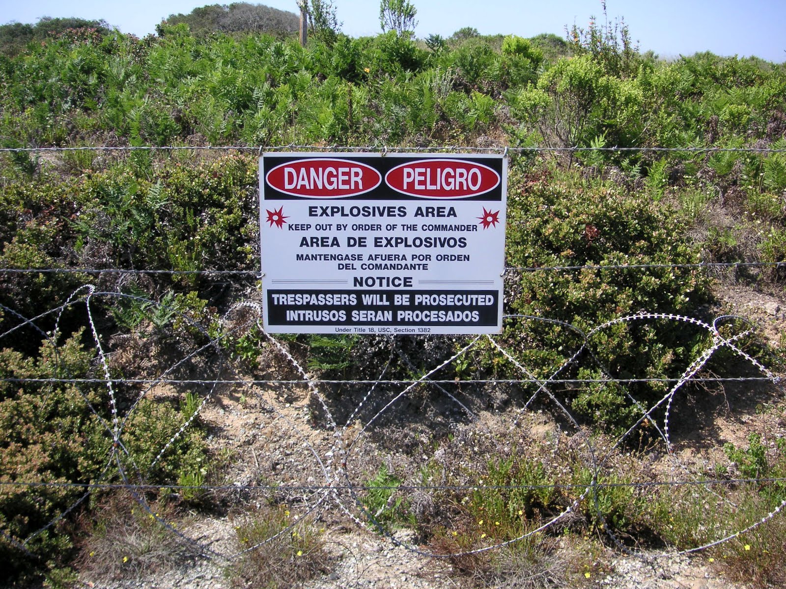
I've mentioned several times about UXOs at Fort Ord, both on closed Army Lands (the reason why it's taking so long to make lands available to the public) and BLM trails previously opened to the public (e.g., the last picture from this March 20, 2011 habitat post). I know absolutely nothing about explosive weapons, so I can't figure out how a 3 inch (<8 cm) anti-tank rifle grenade can be so large - my hand span from thumb to forefinger is 6 inches (~16 cm). I regularly see small bullets on the trails (e.g., the last picture from this June 30, 2011 habitat post) most often from the InterGarrison side of the BLM lands. I know some people who like to collect the bullets they find on the trails, which I consider rather peculiar. Seeing these massive weapons on display makes me definitely want to stay on designated open trails. Eh-hem, hello, mountain bike riders?

2006 burn area - Munitions Response Site (MRS) 16

Our tour route was a little different from last year's Nature Walk. The 2011 autumn burns (from home it would have looked like this October 8, 2010 burn) were cancelled due to the discovery of surface 155mm and 8 inch rounds (equivalent to 20 lbs. of ammunition in each - Holy Toledo!... or is that holy torpedo?) in the planned burn area. Obviously, there were safety concerns, especially with the potential travel distance of the thick metal casings of such massive explosives. I'm not sure how they're getting the rounds neutralized. As a result, we didn't tour a previous year fire area. I was slightly bummed, because I wanted to see fire poppies again. Although, David Styer told me that this spring he spotted a few fire poppies in a 2010 burn area, and they were all finished blooming by now.


2003 burn area - Units 43-48

So, after seeing the ordnance display and knowing we were entering the razor fenced area shown in the first picture of this post (a 2008 Unit 18 burn area, which hasn't been completely cleared of UXOs), I was a little nervous about traversing this section of the tour. As you can see we had plenty of guides, including BRAC's munitions safety fellow Lyle. In the distance are the 2003 burn units, some of which are proposed to be made into commercial or residential areas. Like I said last year, this area is very sandy and can't be compared plant-wise with other units, although most of the rarer plants are here.


the bunker

I didn't get a close pic from last year, so here's one. This is not one of the bunkers that is shown on every PDF trail map of Fort Ord. The solar-powered, tall antenna is for GPS, which BRAC and contractors utilize extensively to map Impact Areas.


2009 burn area - Unit 19

In the first pic of this 2009 burn area, the line at the base of the sandy hills used to have train tracks for soldiers to practice shooting at moving targets. The second pic is to show what I believe could be a vernal pool in a transition area from sand to clay, the two predominant soil types found at Fort Ord.


2008 burn area - Unit 22

Here are pics to compare with last year's 2008 burn area (click photos 4, 8, and 9). Considering the lack of rain this winter, it's not as lush green and the vernal pool is completely dried. Interesting thing though, the flowers in bloom were pretty much the same, perhaps just not as many of them.

Sigh, this was a surprisingly difficult post for me to write. I took way too many notes with all my May tours of Fort Ord. Quite frankly, I'm Fort Orded and grouped out to the max. If I can find time and get back into ID mode, I hope to post individual IDs of new flowers (and animals) for Nature ID. Lately, I've simply been enjoying any time outdoors, alone and away from people, without notes, without camera, and without computers.

the Spirit of Service ~ 05/19/12 ~ Fort Ord National Monument

Charles "Chuck" Haugen

Mudhen Lake

Fort Ord National Monument
May 19, 2012

I took the opportunity right after this year's Fort Ord Army Lands tour (posts yet to come) to drive down Eucalyptus Road to Jacks Road, which were open to the public due to the dedication ceremony for the Fort Ord National Monument that was being held at the same time. I was too late for the ceremony, but it was nice to drive to a location that I have never hiked from the BLM Creekside entrance to Fort Ord. I talk about Chuck's significance for Dr. David Styer in another post from May 28, 2012.

Friday, May 11, 2012

habitat ~ 05/11/12 ~ Fort Ord National Monument

Fort Ord National Monument
aka on Nature ID as Fort Ord - BLM InterGarrison and Fort Ord - BLM Creekside
and eventually parts of Fort Ord - Army Lands
May 11, 2012

This was a most unusual excursion for me, hence why I'm publishing this habitat post before the specific IDs. The IDs will follow in the coming days and will be linked in the section above or scrolled down to be read below.

On April 20, 2012, President Barack Obama signed a proclamation to designate the Fort Ord BLM and Army Lands (only the areas set for open space) as a National Monument. I've linked to all my location posts above that will be included in this new moniker. Plus, there's already a 3-year-old Fort Ord Dunes State Park, and the local California State University, Monterey Bay (CSUMB) has been around for 17 years on former Army Lands. And as I learned recently, there's a University of California Fort Ord Natural Reserve (UC Natural Reserves) managed by the University of California, Santa Cruz (UCSC). However, the rest of the former Fort Ord Army Lands (almost half; it was a very big place) is set for housing and commercial use across city borders and county lands, which continues to create endless local controversy.

Then, yes, despite my protests over the years, I have finally joined a group - the Monterey Bay Chapter (MBC - my acronym) of the California Native Plant Society (CNPS). I've already been to my first monthly meeting and found the people to be very sociable, knowledgeable, and (pardon if I offend anyone) not all as old as I thought they'd be. They threw out scientific names that left my head spinning, but I was surprised at how much I already knew from doing Nature ID. I've thought about why I decided to join this "society" as affable Brian LeNeve pointed out while I proclaimed my hesitation to join any group. Truth be told, thanks to webmaster Chris Hauser, who redesigned the local chapter's website, I easily discovered the calendar of the hikes local CNPS members have, often on private land. Oooh! As you'll notice, about 95% of my locations on Nature ID are from publicly accessible lands. Private access and discount on books convinced me to throw in my $45 for the year. So, there you have it.

As a result, this hike was posted on the calendar as being led by California State University, San Luis Obispo (Cal Poly SLO; there's also a Cal Poly Pomona) professors David Keil and Matt Ritter. I signed up and was told that Bruce Delgado (BLM Botanist and Marina Major - hmm, he'll readily admit that he tries to stay out of conflicts of interest since the city of Marina gets part of the Fort Ord lands) would lead us to the current best vernal pool spots. Little did I suspect that at least 20 Cal Poly undergrads, numerous UCSC grad students, and various other professional folks would also be in attendance. We all rode in a big red fancy bus during the tour with a couple stops here and there. I didn't speak to Dr. Keil (Emeritus Professor), but he is admired by many. Dr. Ritter (Associate Professor) seemed to be absorbing all the information presented as if he were a student. Most of the plant information came from 9-year+ volunteer David Styer, who, in his words, "keeps the official plant list for Fort Ord", which numbers at around 900 species so far. Unfortunately, it is not all included in the official 2012 MBC CNPS Fort Ord BLM Area, Seaside and Marina plant list. I happened to meet Dr. Styer (a former math professor) previously while hiking from the InterGarrison entrance on April 1, 2012 (posts not up on Nature ID, yet).

Matt introduced this tour as the 100th year inaugural phytogeographical excursion of the California Botanical Society (CBS), which are also known as phyto-jogs. There will be 5 phyto-jogs this year across CA. Although, I believe there's already been a joint SoCal chapters' CNPS phyto-jog done down in Rancho Santa Ana Botanic Garden this past March 10th. I'm still trying to figure out the difference between CBS and CNPS.


Butterfly Valley
the most diverse vernal pool and mima mound area at Fort Ord

I believe this mima mound area of Butterfly Valley is off-limits to the public and is on cleared Army Lands. The trail down to it is covered with branches to keep the mountain bikers out. It's also where they trap wild California pigs. I'd hate to be the volunteer who has to carry the several hundred pound dead pig up the hill over the bramble of branches. I'll post special IDs from this location later.


Engineer Canyon Road

David Styer said through his many years of taking inventory, he's found the north-facing slopes seem to have more diversity. He's separated out Fort Ord into around 70 sectors merely based on divisions by roads, not habitats. According to Dr. Styer, this part of Engineer Canyon Road (which is close to where Andy and I used to access Fort Ord before the Creekside entrance was built) has the most plant diversity than any of his other sectors. One of the grad students is hoping to describe a new Fritillaria sp. from here. I'm going to contact him to see if it's okay to post pictures of a plant he's yet to officially describe. If you click on the picture above, there's a fellow with a large white plastic bag filled with collected plants. While some were picking and pressing plants for additions to herbaria collections, I noticed several students simply making cute little bouquets of rare flowers. Seeing the quickly wilting bouquets disturbed my sensibilities, because I was taught never to pick wildflowers.


view of Toro County Park and Mt. Toro

Several of my Fort Ord habitat posts feature vistas of Toro County Park and Mt. Toro in the distance. I have yet to visit either place. Once or twice a winter, including late this past dry winter, Mt. Toro is dusted with snow, which is quite beautiful. It can best be seen from a boat on the Monterey Bay but also from the Hwy 68 ramp off Hwy 1 towards Salinas and, eh-hem, our kitchen window. My favorite view is during peak spring green, like it was on March 14, 2009.

Um, have you read this far, yet? So, I have a dilemma, and I hope to hear some feedback. We signed up for another Fort Ord Army Lands tour for this next Saturday, like we did last year. Unfortunately, the dedication ceremony for the Fort Ord National Monument will be held within the same time and almost at the same place (map to ceremony, but reservations were needed). This seemed like poor coordination between all the different agencies involved. Oh, did I mention it will also be CSUMB's graduation ceremony day? The traffic will be unusually heavy. Andy and I are undecided about which event to attend. We've done the Army Lands burned area tour already, but it would be nice to see the changes after a year, especially after an unusually dry winter. Then, again, how often is a place designated as a National Monument? The ceremony could be really boring with a bunch of endless speeches without any real information. Your opinion?

Saturday, February 18, 2012

habitat ~ 02/18/12 ~ Fort Ord - BLM InterGarrison

Fort Ord Public Lands - InterGarrison entrance
February 18, 2012

Lately, I've been trying to focus on the positive on Nature ID and was hoping if I waited a few days to post about this excursion, my grumpy attitude would mellow out. Unfortunately, I still have pet peeves to report from this hike, and those pet peeves are more hot to me than describing my other photos.

Right as we pulled into the very limited sandy parking at InterGarrison, we met a couple of dogs off leash. As soon as I got out of the car, one promptly stuck its slobbery nose up where it didn't belong, and the other pooped not more than a few feet away in the sand (I was very careful not to step in the steaming pile of poo). I don't blame the dogs. I blame the dogs' owner. The regulation of having a dog under voice command does not mean a verbal remonstration after the fact of "Bad Barkie, leave the nice lady alone!" Plus, the owner made no movements to pick up after his other pet. (Oh, did I mention he was a mountain biker? I'll get to that in a mo'.) At the very least, I'm glad none of the dogs jumped into my car, which Andy experienced a little more than a year ago. When Andy tried to get Lola out of his car, he ended up with his 3rd worst poison-oak rash ever. His arms oozed for weeks thanks to a careless dog owner who couldn't find her way on the trails, let alone find her own dog. Given my last several encounters with dogs on trails (muddy footprints all over me, scaring me during my first ever bobcat encounter, pooping not 3 feet away in the ocean waves from my friend's toddler, and other incidents), really, I do like dogs... just not run amok where common courtesy seems to be forgotten.

There was a ton of poop on the trails. With minimal rain this season, poop seems to be holding its shape pretty well with fuzzy mold. Some were obviously from wild animals with bits of red berries in them, but I'm guessing most were from dogs. Does anyone know how to tell dog and coyote poop apart? Several bikers had dogs with them, and I can't imagine that they would stop their bike to pick up after their pet. As the biker in the parking area demonstrated, he wasn't the least bit concerned about cleaning up after his dog. All that dog poop has got to have a negative impact on the wildlife and the environment.

So, speaking of bicyclists, check out the bright red trail marker above. Can you also see the clear bike tire treads? These trail markers are new within the past couple of months. It's supposed to say "Area Closed," but it's already been defaced. These trails were closed 2 1/2 years ago, and even then the markers were promptly defaced or ripped out of the ground completely. Oh, did I mention? I witnessed the same dog/bike loving fellow promptly go down a brightly marked red trail to enjoy the beauty that is Fort Ord. If he and his cohorts continue, the place may not be so beautiful in the coming years. Considering there are still UXOs being found on previously opened trails, this could be really dangerous. Andy and I don't understand this behavior. We consider it a privilege, not a right, to have access to these lands.

edited 02/25/12 - Now that my rant is done, I've added descriptions for the rest of the photos:

vernal pool

There's a new definition of dry this year. I passed 3 vernal pools during my hike, and they were all this brown without a lick of water. Even on August 4, 2010 there was more green here. To see how filled with water the vernal pools can be, check out my March 20, 2011 post. Let's do a rain dance to get a flood of rain in March and April. Interestingly, I heard several frogs during this hike. I don't know where they'll lay eggs if there isn't some rain soon.


green grass under coast live oak

For how dry it was, I was impressed there were areas of new green under the tree canopies. The tree provides shade and extra moisture collection from fog and rain to the understory. I've asked this before, but what's the term for this natural occurrence? Is it a combination of throughfall and fog interception?


rototilled ground

While there are skunks and badgers at Fort Ord, I think the likely candidate that did this were wild California pigs (Sus scrofa), an odd cross between feral domestic pigs and Eurasian wild boar. They've only been seen at Fort Ord since 2004, and more than a hundred have been trapped since 2006. While I've never seen them, Andy has seen several during his many trail runs at Fort Ord.


dusky-footed woodrat house
Neotoma fuscipes

Normally, I'd have this as its own post, but now I'm starting to see dusky-footed woodrat houses as indicators of certain habitats. I most often see them in heavily forested coast live oak areas. I rarely see just one house, and more often than not there's a whole complex of multiple houses. The king of woodrat blogging is Nature of a Man. Check out his blog!


Fort Ord Army Lands

This picture was taken very near where I saw an incredible display of Indian warriors on March 20, 2011. There's a new Fort Ord map as of last September, but we believe it's already out of date. They've done quite a bit of new trail building that will make it easier to get from the BLM InterGarrison side through open Army Lands to the BLM Creekside entrance. I'm not quite sure what this corridor was since it's not a trail; I suspect it was a temporary road that was used for equipment to build the new trails. It's been exciting to see all the work being done to convert Fort Ord into a public access space. I just hope people can respect the land, the life, and the rules so that everyone can enjoy it for years to come.

ps 02/28/12 - Given my pet peeves above, particularly pets on public lands, Shaina of Middle of Everywhere has a decent post about where this might head.

pss 03/14/12 - Well, here's a different idea - just throw the poo into the bushes according to Rambling on...

Saturday, December 17, 2011

habitat ~ 12/17/11 ~ Fort Ord - BLM Creekside

Fort Ord Public Lands - Creekside entrance
December 17, 2011

Truth be told, we didn't actually park at the Creekside entrance for this evening hike. We used the old dirt pull-off on Reservation Rd., which we once used regularly before the BLM built a fancy parking lot with pit toilets on Creekside Terrace, shown in the 3rd photo above.

Speaking of the 3rd photo and 4th photo, that's not the pretty shimmer of water in the distance; it's the extensive plastic that farmers use to cultivate strawberries. Strawberries have been Monterey County's most valuable crop for the past 3 years. I had a friend who recently worked at a small organic farm. Even though they didn't use methyl bromide or methyl iodide, they used several hundred pounds of plastic every year. It was a huge expense for them to dump the plastic at the local waste management, but it was "better" than burning all those plastic chemicals to be released into the atmosphere, which according to my organic farmer friend so many other farmers choose to do to save on costs of dumping plastic. There seems to be something inherently wrong with plasticulture. Needless to say, I've long ago not purchased strawberries, be it cheap supermarket, on the side of the road, or expensive organic farmers' market. I believe the environmental costs are too great for such a small fruit. However, I will eat them if they're offered to me. Hmm, maybe I'll try growing strawberries in my mini-balcony greenhouse... which, guess what, is covered in reused greenhouse plastic?

Wednesday, August 24, 2011

habitat ~ 08/24/11 ~ Fort Ord - BLM Creekside

Fort Ord Public Lands - Creekside entrance
August 24, 2011

We've had so much cold fog here on the coast this past month, that it was very nice to drive 20 minutes inland to experience some sun and heat of around 80°F. I was sweating during my hike and it felt great. Unfortunately, we'll be heading to a family reunion in the Central Valley this weekend where the temp is supposed to be over 100°F. Oy! Oy! So, I'm back to enjoying the refrigerator-like conditions at home. Btw, I've added a little weather widget to my sidebar, so you can see our current weather conditions in Pacific Grove, the southern end of the Monterey Bay.