posted 06/04/12 - We took the same style Nature Walk of Fort Ord Army Lands' Impact Area, like we did last year on May 14, 2011. Once again for the 3rd year running, the U.S. Army's Fort Ord Community Relations Office coordinated this special access tour of publicly closed lands with the U.S. Army Fort Ord Base Realignment and Closure (BRAC) Field Office folks and their "intern" Bart from CSUMB's Coastal and Watershed Science & Policy M.S. program. They also enlisted several volunteers to help lead this year's very large group, including David Styer, his wife Jane, and Sean McStay, Steward of the Fort Ord Natural Reserve (part of the University of California Natural Reserve System). This year was unusual for last-minute coordination with the dedication ceremony of the Fort Ord National Monument, which was being held at the same time through some of the same access roads. I was very impressed with how Bruce Delgado (BLM) and Melissa Broadston (Community Relations) efficiently directed traffic to each event.
Before I write additional details, I should point out to any Nature ID readers that what is presented here comes from my notes of what I believe I heard (remember, I have a hearing impairment) and my own photos from the tour. For official information, visit the following sites: Former Fort Ord Environmental Cleanup (essentially BRAC), Bureau of Land Management (BLM) Hollister Field Office (site currently being updated extensively due to several new land designations), and Fort Ord Reuse Authority (FORA) (to be honest, I don't fully understand what they actually do, but I was eagerly offered a phone number from a fellow responsible for the habitat conservation plan for all non-National Monument areas - it's all being politicized and controversialized, so I'm hesitant to comment on it).
I was pleased to be remembered from last year and to hear from Gail Youngblood, BRAC's Environmental Coordinator, that their online cleanup site visits increased significantly coming from my blog (somehow they can track these kinds of things). She asked me to let people know there will be a free guided bus tour (read: safe and easy) on Saturday, June 23 for folks interested in Fort Ord munitions cleanup. I was also happy to see Chris Duymich, BRAC's Prescribed Burn Manager, who is very knowledgeable about the succession of Fort Ord plant species after fires and mechanical disturbances. She let Jane lead the plant IDs. Jane does not waste time. I also received an invitation from Sean, the local UC Steward, for a personal tour of adjacent land, for which I have yet to take him up on his offer.

 types of ordnance found at Fort Ord
I've mentioned several times about UXOs at Fort Ord, both on closed Army Lands (the reason why it's taking so long to make lands available to the public) and BLM trails previously opened to the public (e.g., the last picture from this March 20, 2011 habitat post). I know absolutely nothing about explosive weapons, so I can't figure out how a 3 inch (<8 cm) anti-tank rifle grenade can be so large - my hand span from thumb to forefinger is 6 inches (~16 cm). I regularly see small bullets on the trails (e.g., the last picture from this June 30, 2011 habitat post) most often from the InterGarrison side of the BLM lands. I know some people who like to collect the bullets they find on the trails, which I consider rather peculiar. Seeing these massive weapons on display makes me definitely want to stay on designated open trails. Eh-hem, hello, mountain bike riders?
 2006 burn area - Munitions Response Site (MRS) 16
Our tour route was a little different from last year's Nature Walk. The 2011 autumn burns (from home it would have looked like this October 8, 2010 burn) were cancelled due to the discovery of surface 155mm and 8 inch rounds (equivalent to 20 lbs. of ammunition in each - Holy Toledo!... or is that holy torpedo?) in the planned burn area. Obviously, there were safety concerns, especially with the potential travel distance of the thick metal casings of such massive explosives. I'm not sure how they're getting the rounds neutralized. As a result, we didn't tour a previous year fire area. I was slightly bummed, because I wanted to see fire poppies again. Although, David Styer told me that this spring he spotted a few fire poppies in a 2010 burn area, and they were all finished blooming by now.

2003 burn area - Units 43-48
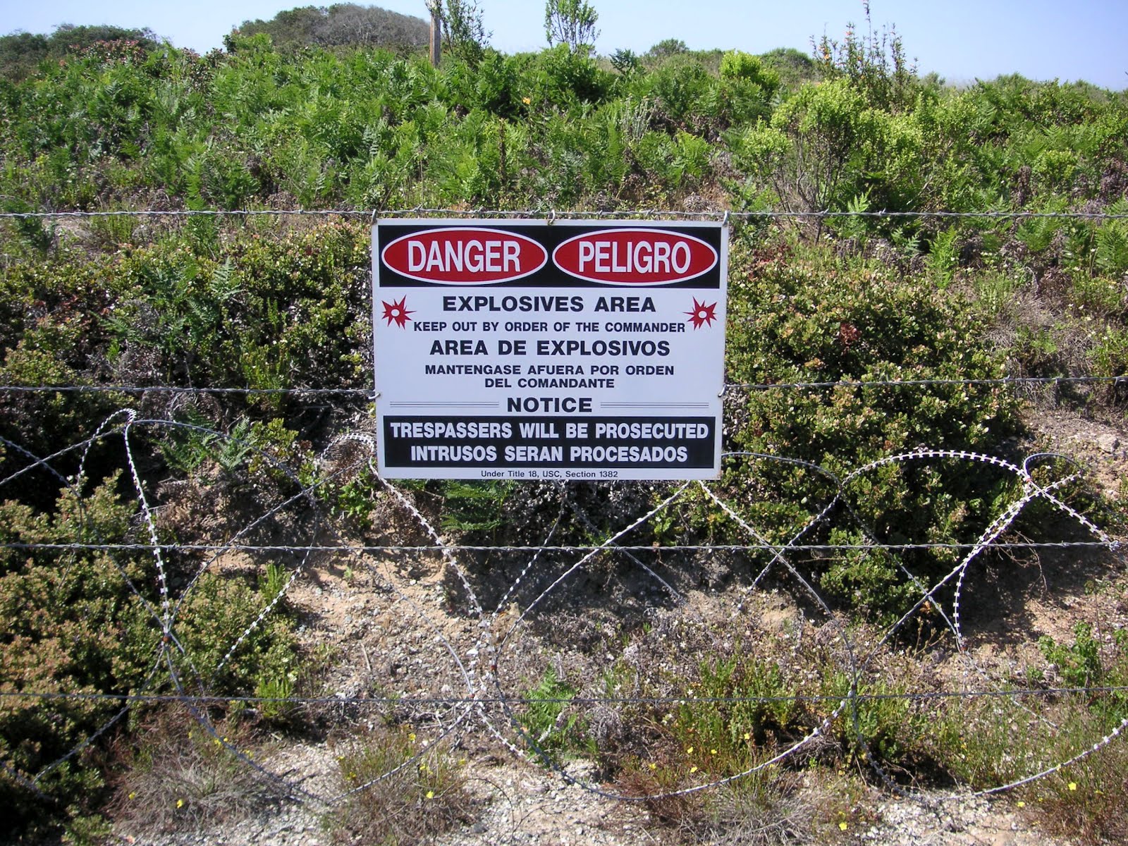
So, after seeing the ordnance display and knowing we were entering the razor fenced area shown in the first picture of this post (a 2008 Unit 18 burn area, which hasn't been completely cleared of UXOs), I was a little nervous about traversing this section of the tour. As you can see we had plenty of guides, including BRAC's munitions safety fellow Lyle. In the distance are the 2003 burn units, some of which are proposed to be made into commercial or residential areas. Like I said last year, this area is very sandy and can't be compared plant-wise with other units, although most of the rarer plants are here.
 the bunker
I didn't get a close pic from last year, so here's one. This is not one of the bunkers that is shown on every PDF trail map of Fort Ord. The solar-powered, tall antenna is for GPS, which BRAC and contractors utilize extensively to map Impact Areas.
 the bunker
I didn't get a close pic from last year, so here's one. This is not one of the bunkers that is shown on every PDF trail map of Fort Ord. The solar-powered, tall antenna is for GPS, which BRAC and contractors utilize extensively to map Impact Areas.


2009 burn area - Unit 19
In the first pic of this 2009 burn area, the line at the base of the sandy hills used to have train tracks for soldiers to practice shooting at moving targets. The second pic is to show what I believe could be a vernal pool in a transition area from sand to clay, the two predominant soil types found at Fort Ord.

 2008 burn area - Unit 22
Here are pics to compare with last year's 2008 burn area (click photos 4, 8, and 9). Considering the lack of rain this winter, it's not as lush green and the vernal pool is completely dried. Interesting thing though, the flowers in bloom were pretty much the same, perhaps just not as many of them.
Sigh, this was a surprisingly difficult post for me to write. I took way too many notes with all my May tours of Fort Ord. Quite frankly, I'm Fort Orded and grouped out to the max. If I can find time and get back into ID mode, I hope to post individual IDs of new flowers (and animals) for Nature ID. Lately, I've simply been enjoying any time outdoors, alone and away from people, without notes, without camera, and without computers.
Sigh, this was a surprisingly difficult post for me to write. I took way too many notes with all my May tours of Fort Ord. Quite frankly, I'm Fort Orded and grouped out to the max. If I can find time and get back into ID mode, I hope to post individual IDs of new flowers (and animals) for Nature ID. Lately, I've simply been enjoying any time outdoors, alone and away from people, without notes, without camera, and without computers.


