Friday, February 28, 2014

habitat ~ 02/28/14 ~ SFB Morse Botanical Reserve


posted 03/03/14 - Rain.  Lots of rain.  Rivers of rain.  Yay!  I got totally soaked, and I loved it.  And, great rumbling thunder, too!... erm, okay, it was a little scary under the towering, swaying Monterey pines.  I've been coordinating another excursion with a fellow blogger, but then it occurred to me that I don't have to drive 2 hours north in order to hike in the rain.  It only takes 10 minutes up the hill by car to get to the end of a PG road where I park.  Then I walk into Pebble Beach to avoid paying the toll road fee ($10!) to get to Del Monte Forest Conservancy property.  Andy regularly runs through here from home.  I should visit more often.  This SFGate article mentions obtaining a "Pebble Beach Nature Trails" map from the local hotels; I always wondered about the colored trail markers but had no idea how to obtain information.  This location includes the surrounding Huckleberry Hill Natural Habitat Area with a cute pygmy Gowen cypress forest.  I  have plenty of IDs to post from this amazingly diverse location, which is being actively managed.  Hopefully, at some point I'll add the details later.  But, for now, I'm off on another adventure...

Tuesday, February 25, 2014

habitat ~ 02/25/14 ~ Pinnacles National Park

February 25, 2014

Researching location labels for Nature ID has had an unforeseen benefit in that I'm now more appreciative of local parks.  I used to take them for granted.  Their ownership and management are not always the same entity and can change over time.  Pinnacles changed from a National Monument to a National Park on January 10, 2013 when President Barack Obama signed an act into law.  (Is this a different legal process than when he signed a proclamation on April 20, 2012 changing former Fort Ord Public Lands into a National Monument? I'm mildly curious to know how all this works.)  Eh, I've been griping about the lack of progress I see around me, e.g., this recent Hatton Canyon habitat post, yet I haven't given enough credit to the changes that have been made.

So, I've added a new location label for Pinnacles National Park.  I'm still undecided if I'll update my past National Monument labels.  For the record, they include:
west entrance location (habitat + IDs)
east entrance location (habitat + IDs)
all Pinnacles habitat
west habitat
east habitat

giant slalom section of the "butterfly highway"

I decided on this last-minute trip to Pinnacles hoping to find 2 specific butterflies before the week's heavy rains hit.  One was the margined white, which is not included in the Pinnacles Butterfly Checklist.  I queried Paul Johnson (it's his list) and Art Shapiro (my go-to CA butterfly expert) about why it might be missing, because there are plenty of milkmaids (host plant) at Pinnacles.  Paul's been looking for over a decade, but he admitted he's had doubts around some look-alike checkered and cabbages he's seen.  Art challenged me to go find them myself.  OK!  Considering I spotted margined at 2 very different locations in the past few weeks, I figured the sooner I get out to Pinnacles, the better chance I have at finding them, if they are there.  Nope.  It's dry.  Very dry.  Very few milkmaids are up yet.  And very few butterflies are out.  Without any clear photographic evidence, I spotted a red admiral, a couple mystery Vanessa ladies, a handful of echo blues, and...

large rocks covered with Dudleya (host plant) and Sedum

... a couple Sonoran blues.  Woohooo!  It's thanks to Ken @ Nature of a Man who sent me a recent picture of one to ID that I even remembered I've been wanting to get a picture of my own ever since Chris Grinter commented on my Dudleya post from 3 years ago.  I was so close to getting a good shot, but then I was afraid of falling off the rock.  You understand.

standard west entrance shot from the parking lot

As I debated whether I wanted to try another trail where I know more stonecrops grow, I marveled at the incredible palette Pinnacles provides even in this record dry winter we've had.  The iron red color of the buckwheats is starting to float my boat.  Given my relative lack of success, I wasn't so gung ho on butterflies anymore.  Plus, I was still feeling kinda icky and was a bit parched and craving the sight of water.  There are plenty of strenuous trails but no connecting roads through the park.  So, in an unusual move for me, I decided to drive over to the east entrance and hike to the reservoir. 

Bitterwater Road

The bleached out grey, died, dead was oppressive, and yet fascinating at the same time because it's so extreme.  I feel badly for the cows and the farmers.  Anyone else hoarding butter in their freezer like I am?  It's going to be worth its weight in gold.

Bear Gulch Reservoir

Ahhh.  It was so worth the long day of driving and hiking through the ick to get here, to this spot, to watch the shadows from the late afternoon sun, and to contemplate life.

Annaphila depicta ~ 02/25/14 ~ Pinnacles

Annaphila day-flying moth nectaring on California milkmaids
Annaphila depicta nectaring on Cardamine californica
Brassicaceae

This is the same sp. moth I photographed on March 4, 2011, but these new macro shots are much clearer.  Three years ago, I had alerted Paul Johnson, Wildlife Biologist for Pinnacles, that it was on the wing.  A couple days later he was able to net a specimen for the Park's collections.  It was a new sp. for him, and he has since confirmed its ID.  Now, he's asked my permission to store my top photo in their wildlife observation files for interpretive/educational use.  Cool.  Not bad for my 10-year-old point-and-shoot.  Paul says his DSLR makes too much noise (slap of a mirror?), which scares off this beautiful moth in a blur.  Fancy-schmancy doesn't always get the goods.  Hehe.

There's also a fabulous fly in the second photo, but I'm ID'd out.  Can you ID?

ps 03/13/14 - I noticed the first set of Hodges 9866 photos in the Moth Photographer's Group by John Davis are misidentified.  I think BugGuide got it right, and they're A. macfarlandi and should be moved to Hodges 9867.  I don't know what happened to MPG, but they don't seem to be curating their collection as well as they used to.  It happens.

fiesta flower ~ 02/25/14 ~ Pinnacles

Saturday, February 22, 2014

habitat ~ 02/22/14 ~ Fort Ord - BLM InterGarrison

 Fort Ord National Monument - InterGarrison entrance

Andy wanted to run some trails, and I tagged along for the ride.  I don't enjoy running like he does, so we often do our own thing.  We've gotten pretty good at setting a time limit and meeting up at the end.  He only wanted to do an 1 1/2 hour run, but I asked to push it to 2 hours (he's so accommodating to my whims) because I thought I'd have plenty of early spring sightings to keep me busy.  Nope.  Oh sure, under the oaks there's a gorgeous flush of green grasses and poison oak, as expected, but out in the wide open spaces...  

... grey, dried, dead.  This year's record-breaking drought has bleached the landscape into a flat monotone wash.  It doesn't even pretend to have the usual golden winter tinge.  Shown here is one of the larger vernal pool sites at Fort Ord.  Um, nope.  To compare how wet this spot can be, check out the 2nd picture from my habitat post taken March 20, 2011.

I headed directly to a road lined with large lilac trees (Ceanothus sp.), because I was hoping to see blooms considering the Ceanothus in gardens around town are going gangbusters right now.  Um, nope, again.  Grey.  Dried.  Dead?  In my head, I rationalized the moderate amount of rain 2 weeks ago was enough to kick things into gear.  It looks like it's going to take a lot more rain to catch up to what I expect.  I'm hoping this is not becoming the new normal.

So, I'll admit I've been in a bit of a foul mood lately, which may just be an annual February thing, but... Argh!  Seriously?  Once again there are new closed trail signs, this time "No Trespassing", and once again they're being promptly vandalized.  Many of the metal signs were completely ripped off their hefty posts and tossed into the poison oak.  In the summer of 2009, the BLM first started adding "closed trail" stickers to their brown trail markers, which were ripped out by May 2010.  Then sometime during the winter of 2011-2012, somebody added new "area closed" red markers, which were defaced immediately by February 2012.  I say "somebody", because I'm not sure if it was the BLM or the owners of the neighboring private property, who apparently host bicycling races as I discovered this day with all the traffic.  Was there a transfer of land somewhere in the last 5 years?  I don't know.  You gotta figure the signs are spendy to make and install, and I just don't see how vandalizing them is productive in any way. There's obviously a kerfuffle going on.  Look at the tire tracks behind the sign.  There you go.

coast live oak ~ 02/22/14 ~ Fort Ord

Fagaceae

I don't know why I keep getting tripped up on coast live oaks, as is evidenced by my past posts March 20, 2011 and March 11, 2012.  In the comments section, Cindy @ Dipper Ranch has provided quick tips on oaks, but my mental block around trees keeps me from remembering most of it.  I now know to look for "underarm hair" on the underside of leaves.  It seems to me that our CA native oaks have a greater degree of variation within spp. than between spp.  Every time I think I've found a different sp. of evergreen oak, it ends up being a coast live oak.  Ugh.  These two sets of photos are two trees growing about 20 feet apart.


Underarm hair?  Check.  But, look how smooth the trunk is, akin to how smooth the leaves are with very few points on the leaf margin.  I know the number of points can be variable, but the trunk, too?  Can anyone confirm for me that this is coast live oak?  Cindy?

For my future reference, and maybe yours, too:
California Oak Identification @ University of California Hastings Reserve
California Native Oaks @ Las Pilitas Nursery 
Oak Identification @ University of California Cooperative Extension, Marin County

Friday, February 21, 2014

western blacklegged tick ~ 02/21/14 ~ Hatton Canyon

female western blacklegged tick (lookalike in eastern US - deer tick)
Ixodes pacificus (lookalike in eastern US - Ixodes scapularis)

posted 02/27/14 - I remember hearing adult female blacklegged ticks are about the size of a sesame seed, so I thought I'd compare.  Yep.  It's 2 or 3 mm long, depending on if you include the relatively massive mouth parts.

She is my souvenir from Hatton Canyon.  Within 4 hours after strolling through the canyon, my left side began to feel really sore, as if I just had a vaccine shot that gives a strong punch.  I've been generally achy all over anyways due to lingering bike accident injuries, so I kind of brushed it off.  But it kept hurting more and more, so I took a look in the mirror.  Heey, I don't have a mole in that location.  What is that?  Ooof, a tick!  

My immediate reaction was to pull it off immediately.  I think you're supposed to be careful in how you do it, so as not to break off mouth parts or inadvertently squeeze any potential bacteria into the bite wound.  Eh, that's not my instinct.  Get it out, now!  I broke a couple of her legs in the process, as you can see in the picture.  It amazes me how they can get their mouth parts so far into the skin.

I've only ever been bitten by a tick twice before (that I know of), once on my eyelash line while camping on a friend's farm in southern Ohio (I thought the shadow in my view was a crusty chunk of sleep), and another in my butt crack from a day trip to Rocky Creek (it felt like a wedgie). Neither of those bites hurt at all.  So, I was really surprised at what a punch this one gave me for a little more than 24 hours after tick removal.  I kept saying, "I can't believe how much it hurts."  Thankfully, it doesn't hurt at all now.

I'm generally pretty diligent in doing tick checks, which can also be fun with a partner. Who knew "tick check, tick check" could be a bedroom call?  Eh-hem.  But this time, it didn't occur to me I had been on a "hike", so I didn't check, even though Hatton Canyon habitat matches tick territory to a T.  Doh!

bite site on torso 24 hours after removal of tick

No, that's not my boob.  Had to use a flashlight to get a clear shot of the bite site.  It's exactly the diameter of a pencil eraser.  I'm watching it for infection or a bull's-eye ring. Although, the hypochondriac in me is convinced I'm developing symptoms of anaplasmosis.  I have been feeling less than spectacular this week.

There are a surprising number of tick sites online, and who knows how reliable most of the chat community compiled information is anyways.  Lyme disease gets a lot of publicity, but it's not the only tickborne disease.  In addition to my standard links in the ID above, I want to call out a few reputable sites by name (click around, they did an excellent job!):

And lastly, for a parasite souvenir to beat them all, check out fellow blogger Camera Trapping Campus' bot flies from Belize.

ps 03/08/14 - TickEncounter contacted me fairly quickly confirming my ID and asking what type of seed was in the picture I submitted via their online form.  I replied with a link to here.  Whoa!  Whoever is writing me sure has a lot of character.  S/he is incredibly interested in Garrapata State Park, which means "tick" in Spanish.  I gave them local CNPS and FOG contact information, folks I figured would be most familiar with Garrapata's ticks.  They also asked me if they could adapt my blog post for TickEncounter.  Sure.

With their permission and edit (which I found curious), here's what they said, "Thanks Katie for the backstory. One of those other tick bites must have been a western blacklegged tick, too. That earlier bite "primed" you to react like you did.  Our studies suggest strongly that a certain protein or proteins in the tick saliva stimulate an IgE response. On re-exposure, the antigen-bound IgE also binds to basophils through their Fc receptors, activating the basophils to release their "payload" of histamine and other cytokines--resulting in the immediate type hypersensitivity rxn that your body so aptly displayed.  Itching from a tick bite might seem annoying but hey, if it helps alert you to the tick so you can promptly remove it then maybe its a good thing." 

Well, I have to say I wouldn't call the pain I felt with my bite as "itching".  In any case...  Doh!  A classic Jones-Mote levels of hypersensitivity!  That's why I didn't have a reaction from the first bites of 2 different species of tick, my body hadn't made antigens yet.  It's interesting that my initial lack of reactions look like they're specific to the type of tick (Ohio does not have I. pacificus).  I barely remember this from my Medical Entomology class (I think professionals use another reaction model now besides Jones-Mote), but the first time someone gets bitten by certain insects and related, they will not have a reaction.  None.  I'm serious.  Hence why I think so many diagnosed with Lyme disease never even knew they had been bitten by a tick.  Given enough time (~2 weeks?) for the body to create antigens, there will be an immediate reaction upon the 2nd bite.  More bites?  Then a delayed reaction after a day or more.  Eventually if bitten, like constantly, the body will go back to not having a reaction at all.  Crazy, huh?  (Disclaimer: I could totally be recalling this incorrectly, but I can't find anything online that isn't bogged down in immunoglobulin gobbledygook.)

habitat ~ 02/21/14 ~ Hatton Canyon State Property

Hatton Canyon State Park Property
February 21, 2014

Heavy sigh... patience is a virtue I am frequently short on.  Whatever happened to the plans to pave a bike trail here?  Does anything ever get done anymore?  Seriously, I look around at every level of government and wonder how do we actually make progress?  How did they do it during so much turmoil in the 30's and 40's?  My uncle, the archetypal retired history teacher, talks all the time about how our current situation parallels that era.  I don't have an answer, mainly because there's so much I simply don't understand.  I'm putting all my faith in the people who claim they want to figure it out and get it done, i.e, elected officials.  Groan.

Where was I?  Oh, yeah... the best accounting of the bike path drama I could find is this July 23, 2008 Herald article hosted by the Transportation Agency for Monterey County (TAMC).  Erg.  I'm totally guessing a handful of homeowners may be threatening a lawsuit that CA State Parks can ill afford, if it's not currently being battled out.  I'm not sure why I hold such a bad opinion of some local homeowners, but, in their defense, they're often unduly cowed by the cities they live in.  However, they already won in court while rejecting a Hwy 1 reroute through Hatton Canyon back in 1997.  I'm glad they saved the canyon, but the predicted result has been horrific highway gridlock, especially around the high school and during regular commuter hours.  My understanding is that as part of the agreement of land transfer from Caltrans to State Parks in 2001 (scroll halfway down page), the bike path legally has to be put in as a condition of not building the Hwy there.  Poor State Parks can't even provide an online description of Hatton Canyon after 13 years.  So, who has more rights, the homeowners with all their negativity towards change, who I might point out technically do not own Hatton Canyon, or the people of California?  Who has more money?

As a daily user of the extremely successful Rec Trail, I am totally for this new bike path.  Currently, there is no easy way to get from Monterey/PG to the Mouth of the Valley by bike or on foot without having to traverse busy sections of Hwy 1.  Andy and his Saturday morning, trail-running cohorts have tried several times to find a better route, with no success.  I'm sure there are plenty of people who would prefer biking to work or school through a beautiful wooded area, rather than sitting in stinky exhaust, standstill traffic.  Isn't that a good thing?  For every commuter bicyclist, there's gotta be one less car on the road.  I would think the surrounding homeowners would find they prefer reduced traffic congestion and a way to get from place to place without getting in the car themselves.  Maybe the problem lies in connecting the trail safely on the north end, closer to Hwy 68?

As it is, Hatton Canyon is being used as a personal dog pooping park with private trails to many backyards.  I'm wondering if someone with enough money wants to keep it that way, despite the total neglect otherwise.  Fortunately, I saw very little dog poop this time compared to the first time I visited Hatton Canyon.  I don't know if the new dog poop bag dispensers have anything to do with the improvement.  Who pays and supplies the bags?  The whole thing is ironic, because there's been so much vocal opposition to putting in a dog park in Carmel Valley.  Obviously, our area needs one.

I'd love to see some attention and management paid to this lovely spot.  There is so much potential!  Here's the Carmel Area State Parks General Plan from 2012 that looks interesting. As I was searching for information, I noticed the Big Sur Land Trust has quietly removed themselves since the last time I wrote about thisRana Creek has been involved, too.  Their work is distinctive, and I've seen them really grow as a company in the 11 years I've been in the area.  I personally think the Monterey Peninsula Regional Park District (MPRPD) would do an excellent job at balancing nature, access, and the neighbors at Hatton Canyon, but it's not their property to manage.  However, this kind of arrangement is not without precedent - the Morro Bay Golf Course is run by the San Luis Obispo County Parks on CA State Parks property.  If given my druthers, an agreement between MPRPD and CA State Parks could be a great solution.

Sigh... it's been difficult to find any information, so I honestly don't know what the current situation is.  I'm writing someone, TAMC or the District 5 County Supervisor Potter, to find out.  It's such a shame this lovely public land isn't being better utilized.

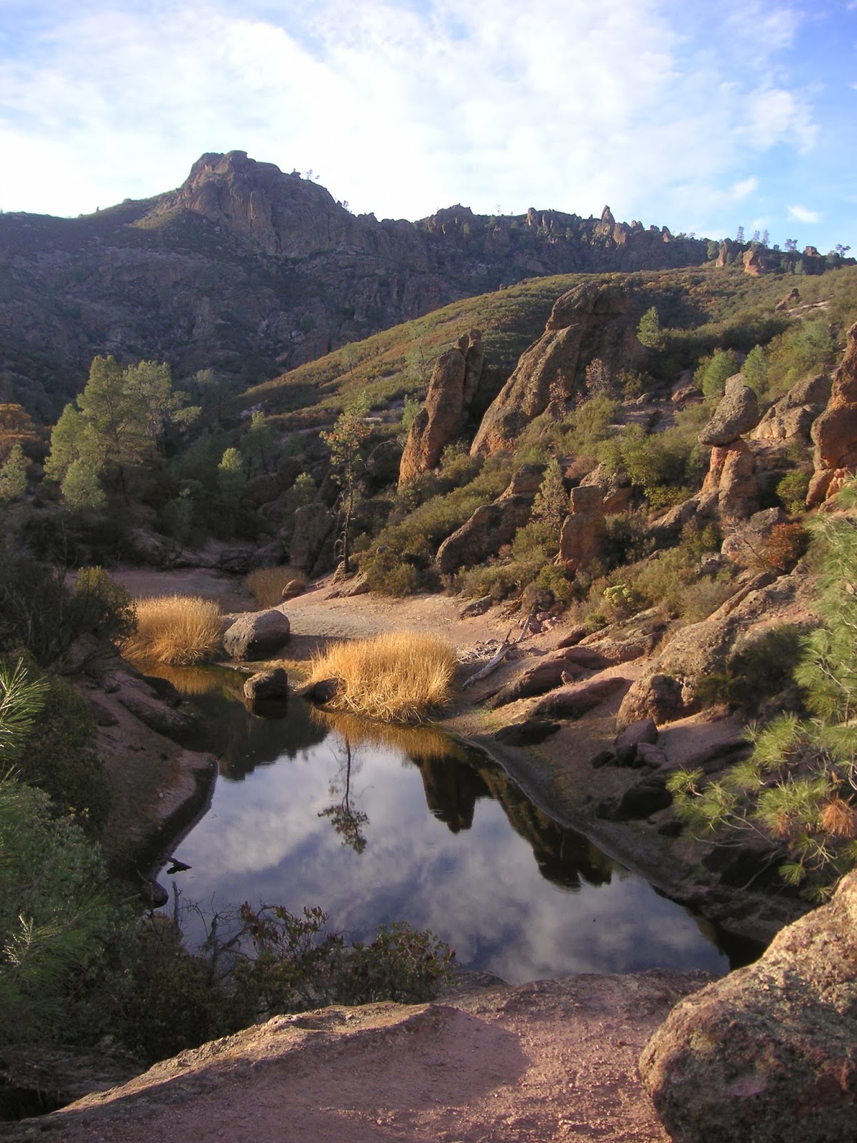
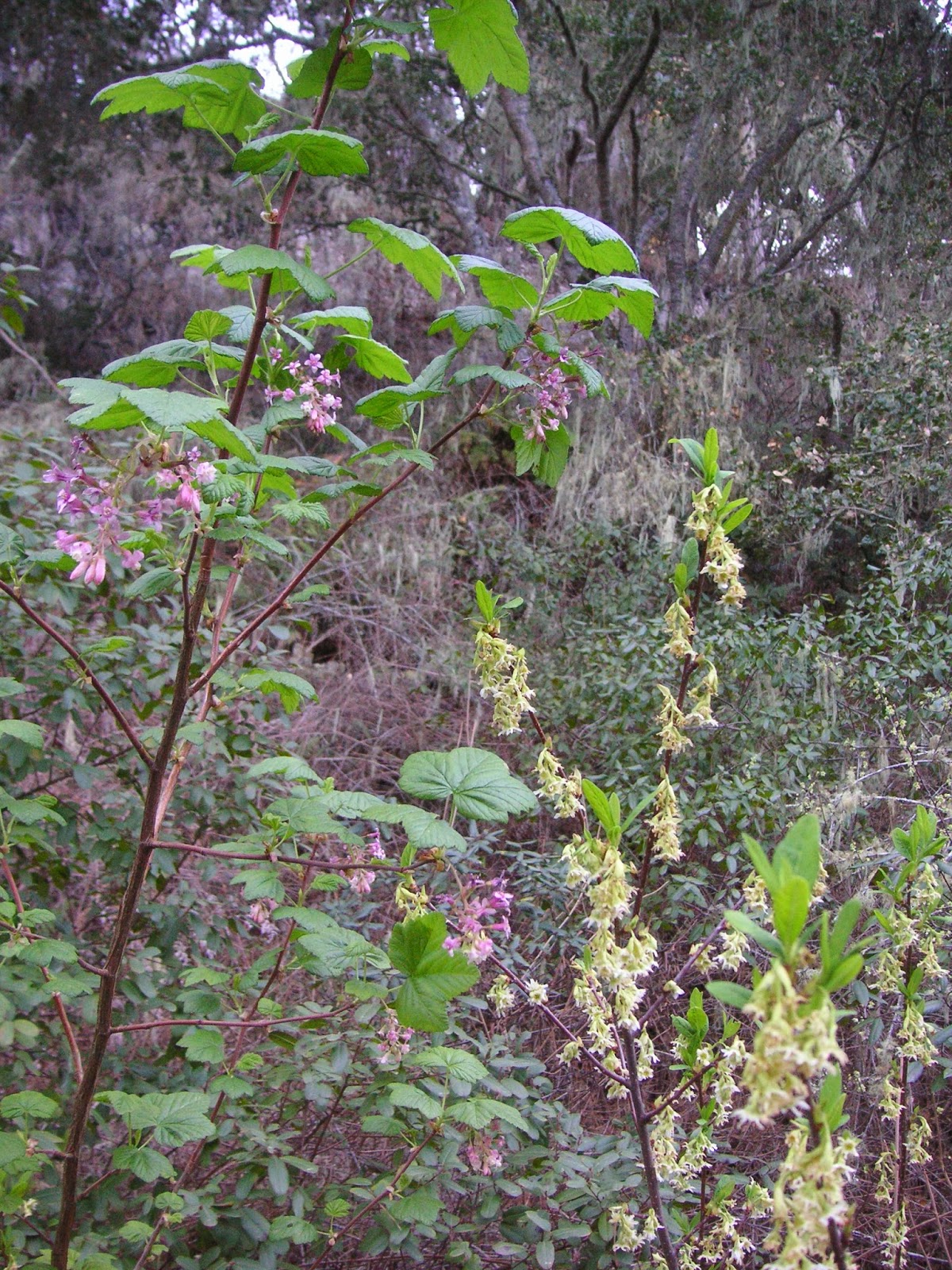
Some things to note on my pictures above...  It just occurred to me that the year-round crick of water is Hatton Creek, which provides a lush green that is hard to find right now during our severe drought.  Someone must be using this water, because there are pipes and manholes scattered throughout the property. Are the Hatton Canyon environmental lawsuits a facade for water rights?  I'm not serious, but nothing would surprise me anymore.  I'm including the oaks above, because I've neglected them in previous habitat posts.  And, the Monterey pines are looking sorry indeed with lots of dried up parts.  I'm looking forward to more rain.

ps 02/27/14 - I apologize if anyone's blog feed got messed up.  I edited this a gazillion times, because I kept finding biased errors in my assumptions.  I feel a sense of responsibility in getting my facts straight when expressing my opinions.  I'm sure there's a lot I don't understand.

Todd Muck, Deputy Executive Director of TAMC, kindly replied to my query and gave me permission to quote him on my blog.  He said, "Due to the opposition to converting the dirt service road into a paved bike path, the Transportation Agency for Monterey County's Board of Directors elected to not construct that portion of the project when we constructed the tunnel under Carmel Valley Road and the paved path to Rio Road.  The unpaved portion remains in TAMC's Bicycle and Pedestrian Master Plan as a potential future project, but there is no longer any funding dedicated to pursing the project."  He also pointed me in the direction of Victoria Beach, a Carmel City Council Member, who's organizing a citizens trails group.  Interesting.  I'll check it out.

oso berry ~ 02/21/14 ~ Hatton Canyon

Rosaceae

Here's another shrub I've wanted to ID for a while.  It's delicate and pretty and one of only a handful of plants in bloom right now.  We noticed the oso berry tends to grow in the same spots as the pink flowering currant.  Oso berry is missing from the local CNPS Hatton Canyon plant list. Las Pilitas Nursery (linked in the aka above) states, "Crushed foliage smells like a green watermelon."  Oooh, I'll have to take a whiff the next time.

Victorian box ~ 02/21/14 ~ Hatton Canyon


I've seen this large shrub at different locations and wondered what it was.  My first thought when seeing it is coffeeberry.  Nope.  When it's in bloom, it reminds me of an orange tree.  And, I've tasted the bright red seeds.  Blech!  After several half-hearted attempts at IDing old photos, I finally resorted to a google image search for "orange berry tree wide wavy leaves".  Ta-da!  (Goodness, what did I do before google?  Anyone remember the World Book encyclopedia?)  I liked Trees of Santa Cruz County's blog post on Victorian box.  This garden escapee hails from eastern coastal Australia and has been locally reported at Jacks Peak and the Frog Pond.

CA manroot ~ 02/21/14 ~ Hatton Canyon

Marah fabacea (aka M. fabaceus)
Cucurbitaceae

My friend thought this was the dreaded cape ivy (Delairea odorata), because of the shape of the leaves and the viney way it was growing.  It does look similar.  However, I was pretty sure it was wild cucumber, but realized I never really paid close attention to either plant before.  If I hadn't found the prickly fruit, I might have been convinced otherwise.  Really, what do I know?  I'm continually learning.  There are 5 spp. of Marah found in CA, and the relatively flat corolla (rotate vs. cup-shaped) tells me this is M. fabacea.  Btw, cape ivy has yellow flowers and shiny leaves

Sunday, February 16, 2014

habitat ~ 02/16/14 ~ Los Padres Dam

Los Padres Dam

The Los Padres Dam along the Carmel River is owned by California American Water (CalAm) and is one of several trailheads to the Ventana Wilderness of the Los Padres National Forest.  While it's a popular backpacking destination, I don't particularly have any desire to go myself: it's drier than I prefer; there are way too many mosquitoes, ticks, and poison oak; and quite frankly, some of the die-hard Big Sur folks make me a little nervous.  We've only ever done the Carmel River Trail for very enjoyable short day hikes.  I'll admit I'm woefully ignorant of the heated water politics surrounding the Carmel River, and it's always in the local news.  CalAm is currently removing the San Clemente Dam located downstream.

ps - Does anyone know what causes the orange colored seepage?  Iron bacteria?

margined white ~ 02/16/14 ~ Los Padres Dam

female margined white / grey-veined white
female Pieris marginalis venosa (aka Pieris napi venosa)

nectaring on Cardamine californica
Brassicaceae

Check out the cool yellow "shoulder" in the first pic above.  I'm so glad we finally found the macro setting on our ol' camera!  A small patch of milkmaids near the water was a very popular nectaring spot, being visited by butterflies, bee flies, and honey bees. There's not much in bloom, so it's worth noting that just down the way the patch of western coltsfoot had no visitors.

I also spotted margined whites at Stevens Creek last week, which at first sight I knew were related to cabbage whites (look at that dot on the male), but second guessed myself when I went to look for an ID.  I've totally missed the margined white ID before based on the fact I rely heavily on two quick references which omit entirely or misrepresent the early spring, first brood, bold version that I find in the area.  The summer brood is apparently almost all white.  It doesn't help that there doesn't seem to be much consensus on the Pieris "napi" complex.  I need to add notations to my field guides, so I can remember this for next time.

bald eagle ~ 02/16/14 ~ Los Padres Dam


What a nice surprise!  I almost didn't believe it.  This bird was massive with an all white head and all white tail.  I didn't even know we could find bald eagles in Monterey County, because I usually associate them being further north starting near Oregon. Now, I wonder how many I may have seen in the distance riding air currents and mistook for turkey vultures.  I'm almost ashamed to admit how little I know about the bald eagle story here on the Central Coast.  This blog post is as good of an excuse as any to read up on this delisted federally endangered and currently state endangered national symbol.  It's interesting how the bald eagle was extirpated from the county back in 1934 and reintroduced by the Ventana Wildlife Society starting in 1986. Monterey Birds 2d ed. by Don Roberson has an excellent accounting of bald eagles and their nesting history in the county.  Don confirmed to me that they are indeed rare at this location.

western coltsfoot ~ 02/16/14 ~ Los Padres Dam

Asteraceae

Not much was in bloom, just a couple small patches of white flowers: milkmaids, miner's lettuce, and this.  On first glance I thought it was cowparsnip (Heracleum maximum), but the flowers didn't look quite right to me and there weren't any leaves. After I got home, I flipped through my Wildflowers of Garland Ranch by Michael Mitchell and Rod M. Yeager, my personal favorite local flower guide.  I double-checked online (see embedded links in the ID above).  Michael and Rod also do an impressive online MontereyWildflowers site that I tend to forget exists.  It looks like they've made a lot of improvements in the past few years.

CA newt ~ 02/16/14 ~ Los Padres Dam

Taricha torosa
Salamandridae

Well, color me orange!  More newts!  This seems to happen to me all the time; once I see something and learn to recognize it, I tend to notice a lot more of them.  We found a couple dozen, and in much drier areas than I would ever expect to see them.  Click on the picture above to take a closer look at the amazing newt iris.  Very cool.

possible rough-skinned newt intergrade?
possible Taricha granulosa intergrade?

Supposedly, rough-skinned newts have not been found in this area before, but I'm still closely examining my photos with Gary Nafis' Taricha spp. comparison.  I dunno, do the eyes "extend past the margin of the head"?  Would it help if I said the lower eyelids on this individual were ambiguously dark?  Erg.  Erg.  Erg.  I may have to throw in the towel on being able to separate the 2 spp.


How many newts?

Answer: 2.  It could well have been the different lighting and moisture level (sunny vs. the overcast skies under tree cover at Stevens Creek from last week), but it seemed to me the newts here at Los Padres Dam have more of a reddish coloring on top.  In fact, I'd say their red was almost a perfect match with the madrone bark.

in the Carmel River

Good-bye, newts.  See you next time.  Have a lot of love and lay a lot of eggs.