Fort Ord - Army Lands
May 14, 2011
Thanks to the
U.S. Army's Fort Ord Community Relations Office we joined a guided nature walk inside this non-public impact area (no pun intended). Eventually in 2020 this land will be turned over to the
U.S. Department of the Interior's Bureau of Land Management (BLM) to expand the existing Public Lands to 15,000 acres. I've mentioned a couple times that the Fort Ord BLM Lands are my favorite local hiking spots (
Creekside and
Inter-Garrison), so it was exciting to get a glimpse of what will be.
I can't say I comprehend the process it takes to comply with all the laws and regulations, let alone the basic removal of potential explosives and lead contamination. There are so many entities involved and numerous websites; the best ones I've found are Fort Ord Reuse Authority (FORA) sites,
old and
new, and
Former Fort Ord Environmental Cleanup. The Army's Munitions Clearance Program and
Prescribed Burn Program are closely tied together, so I'll focus on the burn areas we toured.

the
bunkerWe were given a couple route options, and we chose the hike that led up to the bunker where the surrounding areas were burned in 2003 and 2008. While it was a quick pace to keep ahead of the more leisurely group behind us that did not hike up to the bunker, I'm glad we did.

2003 burn area
I suspect this area on top of the sandy hill was a different habitat type than those shown below. Therefore, looking at vegetative growth post-fire doesn't compare for the 2003 burn. Most of the endangered and threatened plant species we saw were found here.

2008 burn area

October 2009 burn area
This was the first year I was at home to see the smoke plume from home. I took a picture and made note of it here on
Nature ID for October 6, 2009.

October 2010 burn area
Again, I took a picture of this particular 2010 burn from home and posted about it here on
Nature ID for October 8, 2010. They also burned in September of 2010. I had expressed an interest to "tag along with the biology folks as they evaluate the September vs. October burn areas next spring." While I doubt a study like this is happening, I was so pleased to see
fire poppies for the first time ever.

planned 2011 burn area in the distance
Yep, there'll be more fires through this decade until at least 2020. The first prescribed burn was conducted in 1997. Imagine over 20 years of regular fire, weather, and wildflower data?
vernal pool with soil excavation in 2008 burn area
The light green area in the center of both photos above is the same vernal pool from different vantage points. In the second photo, there's a wall to the right where soldiers trained to fire into the hill on the left. Due to accumulated munitions, the soil on the hill was excavated to sample and remove lead contamination.
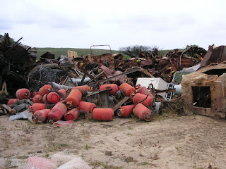
As the cleanup process continues, various Army equipment used for target practice and heavier materials (and illegal dumping like the clothes dryer shown in the middle) get collected here in what is affectionately called the "iron triangle." A contractor will come in to recycle what can be recycled and haul off the rest... except for the
Cold-War era tank 21 (last picture above), which will be kept as a historic display for the BLM. To read more about the history of Fort Ord, check out
The California Military Museum's website.
 sunset from San Carlos Beach


